| Including
Subsets: |
State of Michigan
MSU & East Lansing Other Local Maps |
 |
"A New Map of Michigan with its Canals, Roads & Distances" Published by Thomas, Cowperthwait & Co. No. 253 Market Street, Philadelphia. 1853. [843 D-1853 Michigan] |
 |
"Map of the States of Michigan and Wisconsin" (from 1858) in Mitchell's school atlas : comprising the maps and tables designed to accompany Mitchell's school and family geography. Philadelphia: E.H.Butler and Co.,1866, c1865. [ folio G1019 .M67 1867 ] |
 |
"Map of the States of Michigan and Wisconsin..." in Goode's school atlas, physical, political and economic, for American schools and colleges. Chicago, New York, Rand McNally & Co. 1923. [ folio G1021 .G6 1923 ] |
Michigan State University
and East Lansing
![]()
 |
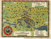
"Michigan State College and East Lansing, Michigan" Designed by James F. Trott. East Lansing, Michigan: Redfern & Reynolds. 1940. [G4114.E4:2M4 1940 T7; 843-d A-1940 Michigan] |
 |
Set of MSU East Lansing Maps:
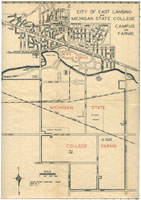
{1}"Michigan State College Campus" MEDIUM VIEW METADATA {2}"City of East Lansing and Michigan State College Campus and Farms" MEDIUM LARGE VIEW METADATA {3}"Michigan State College Serves the Entire State" with College Sub-Stations MEDIUM LARGE VIEW METADATA in Maps and Information of Michigan State College and Vicinity. Maps drawn as an N.Y.A. Project (1941) and revised in 1941 and 1942. [843-d A-1942 Michigan] |
 |
"Garden Beds" in History of Kalamazoo County, Michigan, with
illustrations and biographical sketches of its prominent men and pioneers.
By Samuel W. Durant. Philadelphia, Everets, 1880.
[ F572.K2 D9 ] Bed Layout: MEDIUM
LARGE
VIEW
METADATA |